Submitted by apala-admin on Mon, 08/22/2016 - 20:53
Preliminary flood depth grid and other data relevant to the August 2016 flooding in south Louisiana has been released by FEMA and is available for online viewing and raw data download. These are in addition to maps and data released previously.
Submitted by apala-admin on Fri, 08/19/2016 - 13:47
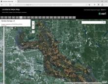
Lynn Dupont has forwarded a link to a mapping application prepared by ESRI's Disaster Response Program utilizing recent imagery provided by NOAA's Remote Sensing Division. This is available for all users. Find the mapping application at this URL:
Submitted by apala-admin on Thu, 08/18/2016 - 14:58
As the flood waters from torrential rains recede from south Louisiana, thousands are affected and in need of assistance. Numerous tip sheets and FAQs are circulating. Below are links to a few.